Twin-Field was established in May of 2026 by my family and I with the goal of responsibly training and applying custom AI.
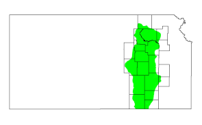
Working to improve spot spraying at our native tall grass prairie farm in the Flint Hills by Madison Kansas was a good place to start.
I wanted to stay on top of my noxious weed problem without killing the good native biodiversity off, so we developed and applied the technology to clean up our own field first.
We did it with our own computers and pictures instead of some giant data center somewhere on the cloud. It was a unique approach that produced unique results.
My neighbor who farmed my field 50 years before I ever did loved the new maps we made.
To return a favor I went ahead and mapped his grazing pasture next. He was amazed.
He showed his one page map off to his grand kid and explained it took over 260,000 pictures to make.
Twin-Field mapping service is here to make a digital twin of your field for you.
We will visit your tall grass prairie field, take a ridiculous number of pictures, process them down, then condense the plant location data into maps for you.
You could be a more advised steward of your natural resources.
Happy to help,
Twin-Field